Morocco, Casablance and the Sahara
Morocco, Casablance and the Sahara
22nd March 2018 to 31 March 2018
Duration: 10 days, 9 nights
Location: Morocco, Africa
Budget: €1750
Miles Travelled: 1970KM
Days: 10
Dates: 22nd March 2018 to 31 March 2018
Tour Company: Morocco Round Trips
Currency: Dirham (10.7:1 exchange rate)
Time Zone Difference : None
Morocco Driving Distance : 1970KM approx
Day 1 – SHANNON – STANSTED
We took an evening flight from Shannon to Stansted with Ryanair. Departure time was 21:15 and we arrived around 22:40 and collected our bags. We got a 3 pound shuttle to the airport hotel, checked in and got to bed around midnight. The shuttle took approximately 5 minutes to get the to hotel and left every 30 minutes .
Day 2 – STANSTED – MARRAKESH
Up at 03:00 to get the 04:00 shuttle back to the airport. This was the first shuttle of the morning. We checked in our bags and proceeded to the gate. No problems with bags or luggage thankfully. Flight time was three hours 30 minutes to Marrakesh. We arrived around 09:45 and went through passport control and got our luggage. Customs checked our bags for drones etc so be sure not to bring any. There is a nice little app called Airmap that you can download for iOS and Android that will tell you the rules and regulation of a country you are planning to visit and if it is allowed to bring a drone with you. We got outside and waited for our collection. The tour operators cannot go inside the airport so you need to exit in order to get collected by your company. Our company was late so we called them and eventually got collected and driven to the Riad in the old town or Medina. We checked in to the Riad Anika around noon and left our bags there. We put the batteries on charge and headed out for a tour of the city with a local guide at 14:00 hours.
Everyone talks about TIA – This is Africa – re timing etc so be prepared to wait around for drivers or guides or tours to run on time according to their website. The weather was nice and warm today so we met our guide at 14:00 and started a tour of the old city – the Medina – in Marrakesh – which is known as the “Red City”. Marrakesh is a former imperial city in western Morocco, a major economic center and home to mosques, palaces and gardens. The medina is a densely packed, walled medieval city dating to the Berber Empire, with mazelike alleys where thriving souks (marketplaces) sell traditional textiles, pottery and jewelry. We visited several main attractions in our afternoon including :
-
- The Koutoubia Mosque, which is an old monument built under the reign of the Almohad Caliph Yaqub al-Mansur (1184 to 1199). A symbol of the city, and visible for miles, is this Moorish minaret of the 12th-century. This monument inspired other buildings such as the Giralda in Seville in Spain and the Hassan Tower in Rabat.
- The Bahia Palace was next on our list. This Palace was built in the late 19th century and was intended to capture the essence of the Islamic and Moroccan style.
- Madrasa Ben Youssef. This Coranic school is named after the Almoravid Sultan Ali Ibn Yusuf (reigned 1106–1142). Madrasa Ben Youssef is the largest in all of Morocco.
- The Saadian tombs, which is a site that dates back to the time of the sultan Ahmad al-Mansur (1578-1603). The tombs were discovered in 1917 and were restored by the Beaux-arts service :
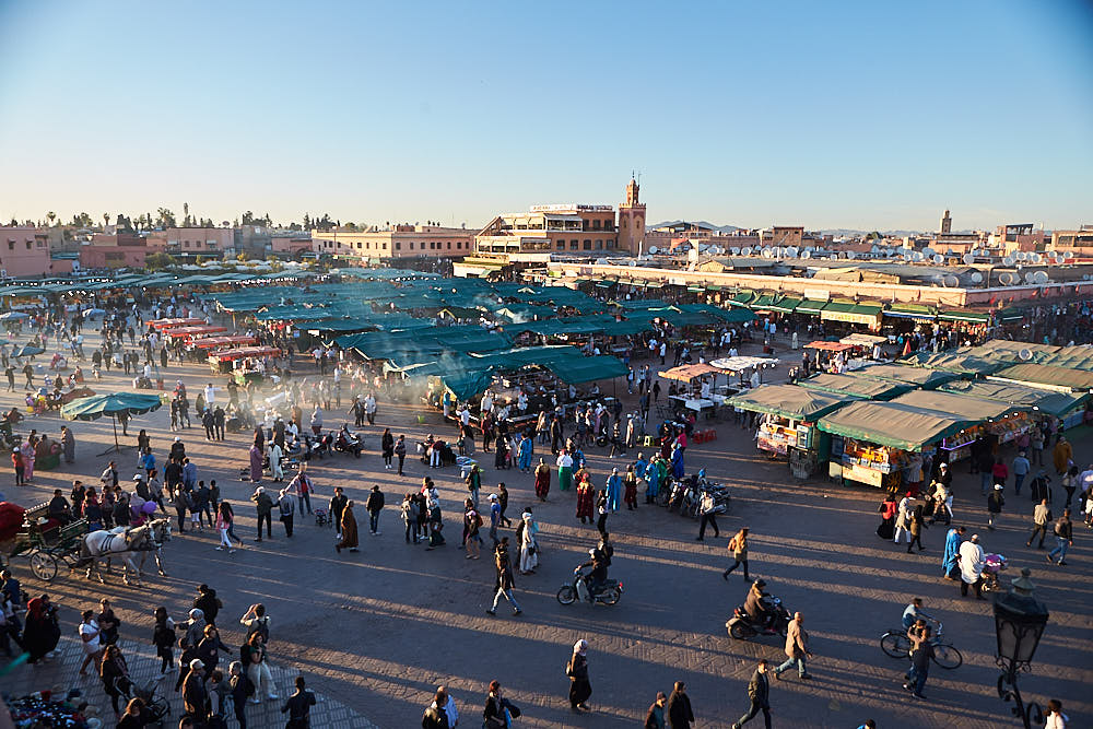
- The world famous Jema El Fna Square where we enjoyed amazing performance of traditional activities by storytellers, snake charmers, peddlers of traditional medicines and the markets. Beware the hawkers and snake charmers – they will give you the snakes to take pictures with and then ask for 200 DH (approx 20 euro) or if they see you taking pictures of other people with the snakes they will harass you for money because you took a picture or video.
After this, we got some dinner, had a drink in the glacier bar overlooking the Jema El Fna square as the sun set and then made our way back to the Riad – approximately 15 minutes walk or 1 mile away.
Day 3: MARRAKECH – CASABLANCA – RABAT (330KM)
After a good nights sleep we got collected around 08:00 and started out on the three hour driver to Casablanca (245KM due North). The roads were good and the weather was nice. One thing that we noticed and were a little surprised by was that everything was so green outside. We stopped for a coffee half way and the lads had a nice crepe and Nutella to keep the hunger at bay. Arrived in Casablanca around 11:15 We visited the famous and the biggest Mosque in Africa, Hassan II, which was built between 1987 and 1993. It is very impressive and vast. We spent an hour here walking around and taking pictures. The last tour at the museum started at 11:00 so we missed this. The tour of the Mosque was not until the afternoon. Check the times before you arrive if you are interested in partaking in either. We then headed to Ricks Cafe – from the movie Casablanca – and got some lunch before driving to Rabat, the capital of Morocco. It took just over an hour to get to Rabat and meet our local guide, Mohamed.
We visited the Royal Gates built in 1864, and enjoy the charming garden of Chellah, surrounded by walls and beautiful defensive gates, built between 1310 and 1330. Later we stopped at Mohamed V Museum built in 1972, and then visited the tombs of Moroccan kings Mohammed V, who died in 1962, Hassan II who died in 1999, the tomb of Moulay Abdullah the uncle of Mohammed VI and Hassan Tower which was built in 12th century. We explored the Oudaya Kasbah which was built in 12th century and served as a military base for the Almorabits army in their defence against the Spanish army. The roof of the Kasbah allows a stunning view of the surrounding area. We also saw the 240km long Abi-Regrag river, located in western Morocco between Rabat and Sala. Overnight in Rabat at the Riad Dar Dar. We had to walk down a few streets and back track a little before we found the Riad – nestled away down some narrow alley and walkway. It was nice inside and we were greeted with the standard Moroccan Tea welcome before checking in.
We got dinner in the Riad and walked around the city’s market streets and bought some trinkets before retiring for the night.
Accommodation : Rabat :www.riaddardar.com

Day 4: RABAT – CHEFCHAOUEN (300KM)
After breakfast we will drive to Chefchaouen, the blue city, through the cities of Khnetra, stopping in Ouazzane, passing by spectacular scenery with cedar, oak and almond trees. We arrived in Chefchaouen around lunch. The day was wet and damp all the way to Chefchaouen. The road had a lot of switch backs, twists and turns and narrow sections and there was a lot of climbing and descending. It is worth taking your time and stopping often to get some air and not get sick. The travel time was around 5 hours from Rabat – including stops.
In the afternoon, we looked around the Blue City. We had lunch in the Aladdin Restaurant in one of the main squares before exploring some more. The rain cleared off but the clouds remained and the temperature was lower than Rabat so we had a jumper and jacket on us for the walk around. Set against a wide valley and nestled between two peaks in the stunning Rif Mountains, the isolated town of Chefchaouen is a surprising delight. Much of Chefchaouen was recreated by Andalusian refugees escaping the Reconquistia, so its striking blue and whitewashed houses, red-tiled roofs and artistic doorways give it the feel of the Spanish hills. We spent the rest of the afternoon exploring the sights, sounds, and smells of the medina, the shops in the square selling woven goods and small sweets, and the town’s famous goat’s cheese. Herds of goats wander the sparse hillsides that surround Chefchaouen, and their cheese is sold in great fresh rounds in the street markets. Within the plaza is the walled fortress of the Kasbah – where you can wander through the tranquil gardens inside, visit the ethnographic museum, and soak in wonderful views from the rooftop. Around 18:00 we visited the Ras el-ma, where the city’s fresh water springs from the mountain. There is a path up the mountain here to give you a panoramic view of the city.
We returned to our accommodation for the night, got some dinner and watched a movie before preparing for the drive South towards the desert the following day.

Day 5: CHEFCHAOUEN – VOLUBILIS – FES (250KM)
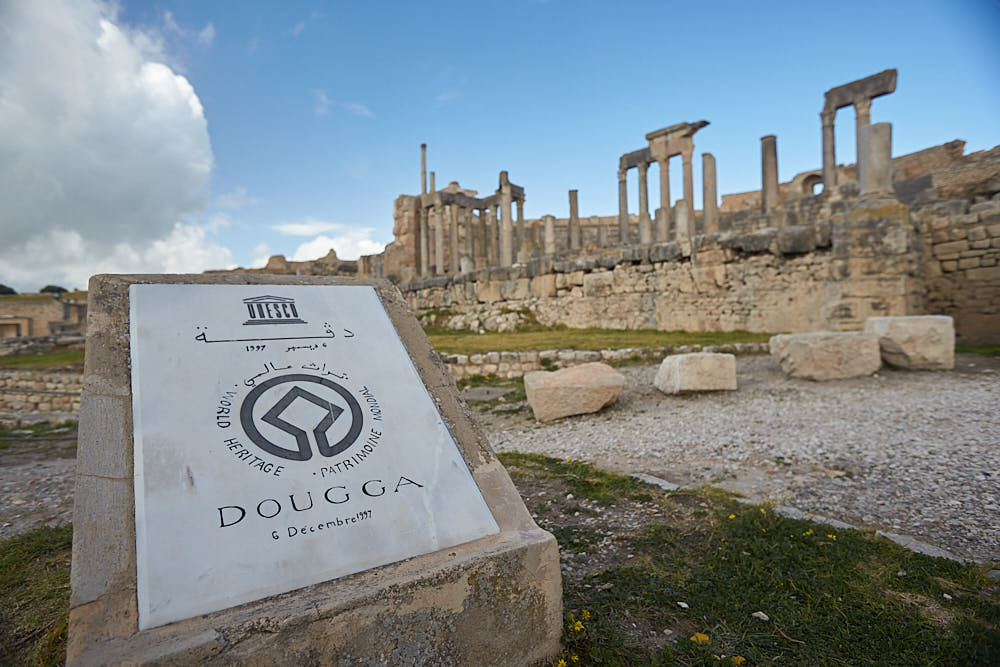
We got up around 06:30 and did an early morning sunrise walk around the Blue City and saw it come to life. After breakfast we descended from the hills and traveled south through the centre of the peninsula towards the sacred pilgrimage town of Moulay Idriss (approximately 3 hours). From here it’s a short journey out to the World Heritage site of Volubilis – meaning Morning Glory. The remains of this Roman city make an undeniably impressive sight as they came into view on the edge of a long, high plateau. We took a 45 minute tour around the arches, basilicas, and superb mosaics along the Decumanus Maximus, many of which remain intact. We then drove onto Fes, arriving there around 14:30. Fes is the spiritual heart of Morocco.
We collected our guide at the Blue gate and started our tour immediately. We started in the Medina – one of the world’s largest walled-in cities. In the south west wall of the medieval Medina is a beautiful looking entry, the Bab Bou Jeloud. It gives excess to narrow streets that are lined up with little stores that sell fresh fruits, spices, woven Berber carpets etc. This medina is very large, approximately 3 km and therefore one of the largest medina´s of the world. We visited the El Qaraouiyyin Mosque, a traditional school, the place Nejjarine and the tanneries. At the tanneries you can watch locals work on skins of goat, lamp, camel and cow, in small clay pits. Sheep is cheap is the famous saying from the tanneries re the hides etc. We saw the Royal gates and had a nice panoramic view of the city before checking into our Riad. There was a problem with the sleeping situation in the Riad and the owner was not very accommodation. We had booked a twin bed and they only had a double available – according to them. Then dinner in Cafe Clock near the Blue gate and walked back to the Riad and slept.

Day 6: FES – MIDELT – ZIZ VALLEY – MERZOUGA (420 KM)
Today was a long day with a lot to see and do. After breakfast in the Riad, we drove south to Ifrane and Azrou through the Middle Atlas Mountains. The air was crisp, clean and fresh. You can feel the altitude when stepping out of the van. The Berber name of Ifrane means caves and it is nicknamed in Morocco as a little Switzerland since it is a very green town and is a ski resort in the Middle Atlas region of Morocco because of its high altitude at 1665 meters. Ifrane is famously known for the Brotherhood Private University, established in 1997 by The King of Morocco Hassan II and the King of Saudi Arabia Fahd – where all classes are taught in English. It is an international university. After Ifrane, we stopped at the cedar forest where we saw the Barbarian Apes in their natural habitat. Then we drove through the Tizi Ntalghamt pass to Midelt. Midelt is in the Middle Atlas and is called “the apple capital”. We got lunch here before traveling along the magnificent Ziz Valley oasis carved through volcanic rock. The Middle- Atlas offers some beautiful views. . Upon approaching Errachidia we saw the scenery change to a dessert environment. Onward we traveled through Erfoud, Rissani and we ended our drive in Merzouga . We arrived here around 17:30 that day.
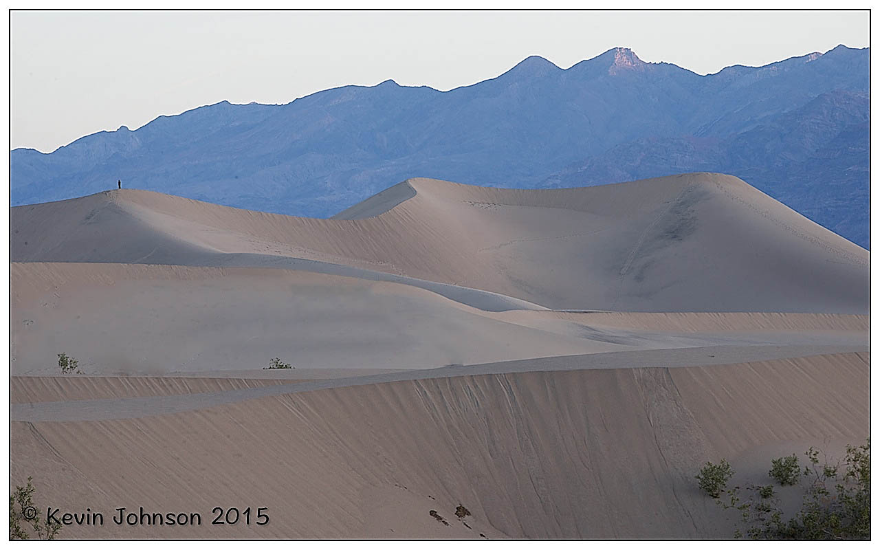
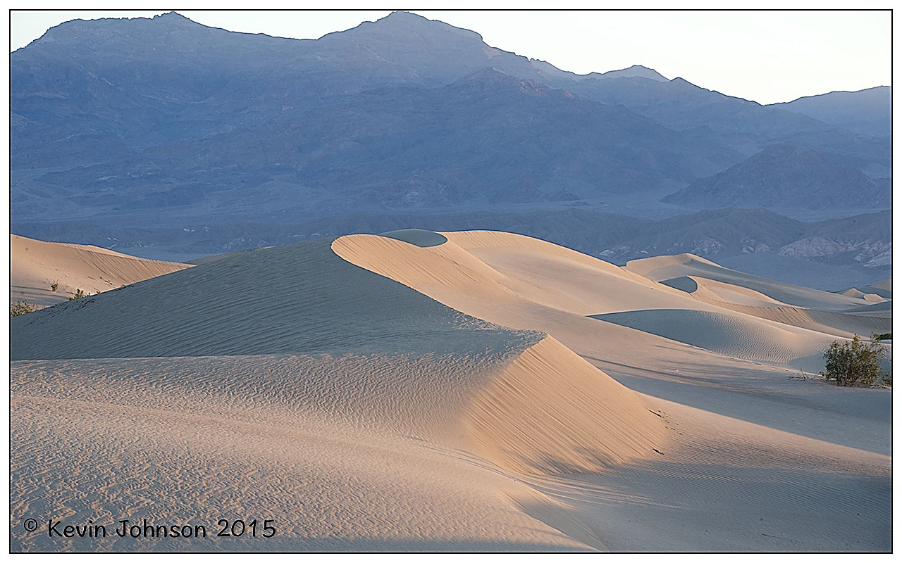
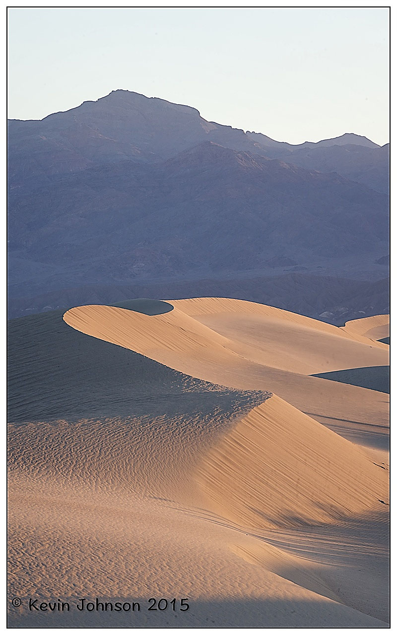
In Merzouga, we mounted our camels and headed off into the Sahara for a spectacular sunset at the Erg Chebbi Sand dunes. Merzouga is the hometown of the Alaouist dynasty, where Moulay Ali sheriff started to unify Morocco under his red flag in the beginning of the 17th century. The camels brought us to a camp in the middle of the Erg Chebbi Sand Dunes. These are the highest sand dunes in North Africa. The camel trek to the camp takes about 60-90 minutes depending on your schedule. Some tour companies get you to camp within 60 minutes and let you climb the closest dunes to see the sun set whereas others will stop en-route and allow you to dismount and enjoy the sunset away from camp. Here, in the middle of the desert we experienced a magnificent sunset and afterwards the sky came alive with stars. .We spent the night in the camp with dinner and live music in the middle of the Sahara.

Day 7: MERZOUGA – RISSANI – ERFOUD – TODGHA GORGES – DADES (280 KM )
We got up for sunrise in the Dunes followed by breakfast and some sand boarding. Then we drove some quad bikes for an hour to get back to town before heading towards Dades. We left Merzouga and headed for Rissini – approximately 30 minutes drive. This silent town was once the ancient capital of Tafilalet and its location is at a crossroads between north and south Morocco. It brought the city to an important status of a former major caravan center. Up to now Rissani remains a major commercial center in the region, with a large souk, particularly lively on Tuesdays, Thursdays and Sunday. It was noted for its leather and goat skin trading in ancient ages. The souk is busy on the other days also and worth a walk around to experience the environment and setting.
After this we traveled to Erfoud. Fossils are a major industry in Erfoud – some 350 million years ago the region around Erfoud was a part of the huge ocean. We got a tour of the facilities and saw how they mine and shape the fossils once they are excavated. On the way to the Todgha Gorges we passed the palm trees groves approx 127 km from Rissini. The great canyons of Morocco – the Todgha Gorges – are situated beyond the central high Atlas Mountains. Here, the contrasting landscapes remind visitors of the Colorado, with its high plateau, its gorges and great canyons, and its peaks sometimes splintered by erosion. Several peaks in this area exceed 4000 m, with Jbel Saghro 2500 m and Jbel Mgoun at 4068 m being the highest peak in this part of the High Atlas. If you look up, you might see climbers scaling the different peaks. The area is populated by Berbers. In the Todgha Gorge we walked through the area and took some pictures before getting back on the road to the next stop. Finally we drove to the Boumalne Dades where we spent the night. Dinner was included this evening – a buffet affair – followed by a walk around the grounds before retiring for the night.
Day 8: DADES VALLEY – OUARZAZATE – AIT BEN HADDOU – MARRAKECH ( 350 KM )
We got up and had breakfast and were back on the road for 09:00. We drove along the road of 1000 kasbahs, since there are enormous Kasbahs on both sides of the road. Some of those old fortified houses are restored but unfortunately a lot of them are in ruins. We drove first to the Dades gorge & valley. Here you saw the rock formations “human bodies, fingers of monkeys “. After a stroll through the impressive Dades Gorge, we’ll drove on to Ouarzazate passing by the valley of the Roses. This valley provides some of the most spectacular scenery of the south, this is where a large part of Morocco’s rose and rose water production occurs. We stopped for a coffee and bought some curios in the local shops. This valley gave birth to a rose from which locals produce different cosmetic products like soap, perfumes and skin creams. Locals here celebrate this rose by organizing a national festival at the end of April every year. We continued along the road of thousand Kasbah to the oasis of Skoura to visit the Kasbah of Amredil. Our trip continued to the city of Ouarzazate, a city of vibrant culture and artistic traditions.
We stopped here for some lunch. First we visited the museum with cinema props and sets from the Hollywood movies. Entry cost for the visit was 30 DH per person. Ouarzazate (Hollywood of Africa, Noiselessly town, The door of the desert), is a city situated in the middle of a bare plateau, south of the High Atlas Mountains. It is mainly inhabited by Berbers, who constructed many of the prominent kasbahs and building for which the area is known.
After lunch we visited the fortified city of Aït Benhaddou, built in the 11th century. Once up on a time this Kasbah was the former caravan route between the Sahara and Marrakesh. It is situated on a hill along the Ounila River and has some beautiful examples of kasbahs, which unfortunately sustained damage during each rainstorm and windstorms. Most of the town’s inhabitants now live in a more modern village at the other side of the river; however, around five families are still living within this Kasbah.
Aït Benhaddou Kasbah has been a UNESCO World Heritage Site since 1987 and several films have been shot there, including Lawrence of Arabia (1962), Time Bandits (1981), The Jewel of the Nile (1985), Kundun (1997), Gladiator (2000) and Alexander (2004). From this beautiful fortified house we went west to the city of Marrakech. It is called the “Homeland of God in Berber”. The ramparts of the town are nearly 30 kilometers long. Then we drove through the Atlas Mountains and saw amazing views. The roads were windy and rough in places so the going was slow and easy for the most part. After driving back over the winding Tizi-n-Tichka pass we arrived back to Marrakech around 21:00. We were staying in the same accommodation as the first night.

Day 9: MARRAKECH – ESSAOUIRA- MARRAKECH (400 KM)
We contacted a tour company earlier in the week and booked a day trip to Essaouira for our last day. The company was late in starting, late getting to the destination and thankfully left on time to get us back home. We drove for nearly four hours with all the stops and getting out of the city. We arrived in Essaouira at 13:00 after stopping for a coffee, a photo of the famous goats in the Argan trees and the shop showing the Argan nuts being ground and made into oils and creams. We went surfing for an hour first – you definitely need a wetsuit if you are going in to the water – and then got some lunch and looked around the Medina before coming back to the bus and departing at 16:00. The area is nice and there are a lot of wind and kite surfers visiting and staying locally. We stopped for coffee on the way back around 17:15 and arrived back in Marrakech around 19:00. We got dropped off in the Jema El Fna square and walked a very similar route to the first days tour before heading back to the Riad for dinner and repacking.
Day 10 MARRAKECH – STANSTED – SHANNON
We got an email from Ryanair re coming to the airport an hour earlier in order to get through security so we left the Riad at 07:30 and arrived at the airport for 08:00. The first queue was to get into the departure section . All bags were scanned and we had to show a boarding pass. Then we proceeded to queue at the desks and drop the bags before heading to the Security check for the next queue. Once through here we went through the biggest queue for passport control and then into the Gate area where we got a coffee and chatted before heading to our gate for the final queue to head home. All in all we needed to be at the airport 3 hours before the flight due to the queues and security checks.
The flight was delayed leaving Marrakesh but we got into Stansted around 15:30 and got our bags by 16:00. We said good luck to Garry and then headed through the bag drop section and security again. We got into the departure section around 18:00, got some food and headed to the gate before getting the flight home to Shannon at 19:55. It was wet and cold in Stansted and Shannon.